बिहार का पर्यावरण संकट: क्यों एक साथ झेलनी पड़ती है बाढ़ और सूखे की मार? जानिए बड़ा कारण और समाधान
03 Jun 2026
जलवायु परिवर्तन के कारण उत्तर बिहार में बाढ़ और दक्षिण बिहार में सूखे जैसी स्थिति बनने की समस्या तथा इसके समाधान हेतु कोसी-मेची नदी जोड़ो परियोजना, सैटेलाइट आधारित चेतावनी प्रणाली और भारत-नेपाल सीमा पर पर्यावरण संरक्षण जैसे सरकारी प्रयासों का सरल विश्लेषण।
बिहार का मौसम संकट: एक साथ बाढ़ और सूखा क्यों? जानिए सरकार की नई योजनाएं और समाधान
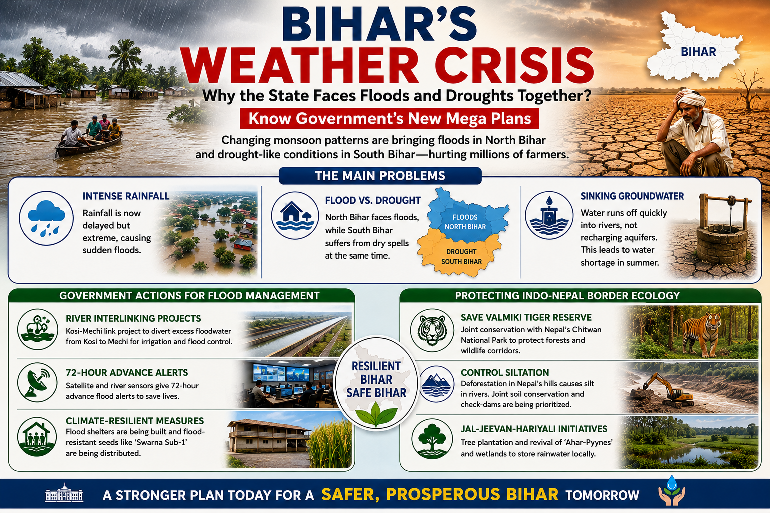
ग्लोबल वार्मिंग और जलवायु परिवर्तन के कारण बिहार गंभीर मौसम संकट का सामना कर रहा है। कई महीनों तक होने वाली सामान्य मानसूनी बारिश की जगह अब कम समय में अत्यधिक वर्षा होती है, जिससे कुछ क्षेत्रों में बाढ़ और अन्य क्षेत्रों में जल संकट पैदा हो जाता है। कृषि-प्रधान राज्य होने के कारण इसका गहरा प्रभाव किसानों और आम जनता पर पड़ता है। इस चुनौती से निपटने के लिए सरकार नदी जोड़ो परियोजनाओं, सैटेलाइट आधारित चेतावनी प्रणालियों और भारत-नेपाल सीमा पर वन संरक्षण उपायों को लागू कर रही है।
🌧️ मानसून में क्या बदलाव आया है? (बड़ी समस्याएं)
- देर से आना, ज्यादा बरसना: अब मानसून बिहार में अपनी तय तारीख से काफी देरी से पहुंचता है। लेकिन चिंता की बात यह है कि जब यह आता है, तो 'क्लाउडबर्स्ट' (अचानक भारी बारिश) जैसी स्थिति बन जाती है। पूरे एक या दो महीने का पानी महज 3 से 4 दिनों में एक साथ गिर जाता है, जिससे नदियों का जलस्तर अचानक खतरे के निशान को पार कर जाता है और फ्लैश फ्लड (अचानक बाढ़) आ जाती है।
- एक तरफ बाढ़, एक तरफ सूखा (The Paradox): उत्तर बिहार (जैसे कोसी, गंडक, बागमती और महानंदा नदी क्षेत्र) नेपाल के पहाड़ों पर होने वाली भारी बारिश के कारण हर साल पूरी तरह जलमग्न हो जाता है। इसके ठीक विपरीत, उसी समय दक्षिण बिहार के कई जिलों (जैसे गया, जहानाबाद, औरंगाबाद और नवादा) में सामान्य से बहुत कम बारिश होती है, जिससे वहां सूखे के हालात बन जाते हैं और धान की रोपनी ठप हो जाती है।
- जमीन का पानी नीचे जाना (Water Table Crisis): लगातार और रिमझिम बारिश न होने के कारण पानी को जमीन के अंदर रिसने (Aquifer Recharge) का समय नहीं मिल पाता। भारी बारिश का पानी तेजी से बहकर निकल जाता है, जिसके कारण गर्मियों के मौसम में दक्षिण बिहार का भूजल स्तर खतरनाक रूप से नीचे गिर जाता है और कुएं-चापाकल पूरी तरह सूख जाते हैं।
🏗️ सरकार बाढ़ और सूखे से निपटने के लिए क्या कर रही है?
- नदियों को जोड़ना (Kosi-Mechi River Interlinking): कोसी-मेची नदी जोड़ो परियोजना का उद्देश्य कोसी की अतिरिक्त बाढ़ के पानी को पानी की कमी वाली मेची नदी तक पहुंचाकर बाढ़ कम करना और सिंचाई बढ़ाना है।
- 3 दिन पहले एडवांस अलर्ट (Advanced Telemetry Systems): जल संसाधन विभाग ने अब आधुनिक तकनीक अपनाई है। सैटेलाइट और नदियों में लगे सेंसर की मदद से बाढ़ आने के 72 घंटे (3 दिन) पहले ही सटीक भविष्यवाणी कर दी जाती है। यह अलर्ट सीधे स्थानीय ग्राम पंचायतों और आपदा प्रबंधन टीमों को भेजा जाता है ताकि जान-माल का नुकसान न हो।
- विशेष फसलें और ऊंचे आश्रय स्थल: सरकार अब बाढ़ प्रभावित क्षेत्रों में ऊंचे कम्युनिटी हॉल (Flood Shelters) का निर्माण कर रही है जहां लोग और उनके मवेशी सुरक्षित रह सकें। इसके अलावा कृषि विभाग किसानों को 'स्वर्णा सब-1' जैसे खास धान के बीज मुफ्त दे रहा है, जो बाढ़ के पानी में 14 दिनों तक डूबे रहने के बाद भी खराब नहीं होते।
🌲 भारत-नेपाल सीमा पर पर्यावरण को बचाना क्यों जरूरी है?
चूंकि बिहार में बाढ़ लाने वाली ज्यादातर नदियां नेपाल के हिमालय क्षेत्र से निकलती हैं, इसलिए जब तक दोनों देशों की सीमा पर पर्यावरण नहीं सुधरेगा, तब तक बाढ़ पर पूरी तरह काबू पाना नामुमकिन है:
- वाल्मीकि टाइगर रिजर्व (VTR) का संरक्षण: पश्चिम चंपारण स्थित बिहार का एकमात्र टाइगर रिजर्व नेपाल के चितवन वन क्षेत्र से जुड़ा है। वनों की कटाई रोकने और वन्यजीव गलियारों की सुरक्षा के लिए संयुक्त प्रयास किए जा रहे हैं।
- नदियों में गाद (Siltation) की समस्या: नेपाल की पहाड़ियों में वनों की कटाई से बिहार की नदियों में गाद बढ़ जाती है, जिससे नदियां उथली होकर जल्दी बाढ़ लाती हैं। इसके समाधान के लिए सीमा-पार मृदा संरक्षण और चेक-डैम निर्माण को प्राथमिकता दी जा रही है।
- जल-जीवन-हरियाली मिशन का विस्तार: सीमा से सटे जिलों में सरकार तेजी से वन क्षेत्र (Green Cover) बढ़ा रही है। साथ ही पुराने पारंपरिक जल स्रोतों जैसे 'अहर-पायन' और तालाबों की खुदाई दोबारा करवाई जा रही है ताकि बाढ़ के पानी को गांवों में ही रोककर स्टोर किया जा सके।
Bihar’s Environmental Dilemma: Understanding the Paradox of Concurrent Floods and Droughts
03 Jun 2026
A simple analysis of how climate change is causing floods in North Bihar and dry spells in South Bihar, along with key government measures like the Kosi-Mechi river link, satellite-based warnings, and Indo-Nepal border conservation.
Bihar’s Weather Crisis: Why the State Faces Floods and Droughts Together? Know Government’s New Mega Plans
Due to climate change, Bihar is facing extreme weather shifts. Rainfall now occurs in intense bursts, causing flash floods in North Bihar, while South Bihar often experiences drought-like conditions. Since agriculture is the state's backbone, these unpredictable patterns heavily affect farmers. To address this challenge, the government is promoting river-linking projects, satellite-based early warning systems, and environmental conservation along the Indo-Nepal border.
🌧️ How Has the Monsoon Changed? (The Main Problems)
- Delayed Arrival, Intense Rainfall: The monsoon now arrives late in Bihar, but when it does rain, it falls with extreme intensity. This sudden downpour causes a rapid rise in river water levels, leaving very little time for administrative preparation and resulting in widespread flash floods.
- The Flood vs. Drought Paradox: North Bihar (the Kosi, Gandak, Bagmati, and Mahananda river basins) suffers from massive flooding due to heavy rainfall in the upper hilly catchments of Nepal. At the exact same time, South Bihar districts (such as Gaya, Jehanabad, Aurangabad, and Nawada) face a severe lack of rainfall, causing drought-like conditions that halt rice sowing.
- Sinking Groundwater Levels: Since the rain falls violently over short intervals rather than steadily, the water runs off rapidly into rivers instead of seeping into the ground. As a result, natural aquifers do not recharge properly, triggering a severe drinking and irrigation water crisis in the summer.
🏗️ What Actions is the Government Taking for Flood Management?
- River Interlinking Projects: The Kosi-Mechi River Linking Project aims to divert excess Kosi floodwater to the water-scarce Mechi river, reducing floods and improving irrigation.
- 72-Hour Advanced Alerts: The Water Resources Department has deployed advanced satellite telemetry networks and river sensors. These tools can predict sudden floods 3 days (72 hours) in advance, sending direct automated warnings to village panchayats and disaster response teams to save lives.
- Climate-Resilient Infrastructure & Seeds: The state is building elevated community flood shelters to keep families and livestock safe during emergencies. Additionally, the agriculture department is distributing flood-resistant seed varieties like 'Swarna Sub-1' rice, which can survive submerged underwater for up to 14 days without decaying.
🌲 Why Protecting the Indo-Nepal Border Ecology is Critical?
Since most of Bihar’s major rivers originate from the Himalayas in Nepal, managing the shared border environment is essential to control floods:
- Saving Valmiki Tiger Reserve (VTR): Located in West Champaran, Bihar’s only tiger reserve is linked to Nepal’s Chitwan forests. Joint efforts are being made to stop deforestation and protect wildlife corridors.
- Managing Heavy Siltation: Deforestation in Nepal’s hills increases silt in Bihar’s rivers, making them shallow and more prone to floods. To address this, cross-border soil conservation and check-dam projects are being prioritized.
- Jal-Jeevan-Hariyali Interventions: Massive tree-plantation drives are being carried out in border districts to enhance green cover. Simultaneously, traditional water storage bodies like 'Ahar-Pyynes' and old wetlands are being revived to trap and hold rainwater locally.